Jeff Bridgman
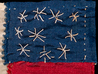
A few weeks ago we looked at Confederate Bible flags, primarily from Jeff Bridgman's stock. Few of the surviving bookmark/flags are associated with their makers or owners but this one was found in a paper album given to Caroline Campbell Morfit (1840-1875) by Confederate prisoners of war housed in the Union prison at Port Lookout, Maryland, grateful to Carrie for her interest in their well being.
New York Historical Society Collection
Point Lookout prison and hospital was an overcrowded facility on a spit of land 20 miles
north of Baltimore.
Why I said North I do not know except you do not want me navigating anywhere. See the correction in the comments: Thanks!
The Point Lookout shown on your map is 185 miles south of Baltimore, MD. It's almost as far south as one can go on the western side of the Chesapeake Bay in Maryland and still be in Maryland.
There's a state park and a National Park Service Confederate Cemetery at Point Lookout.
There's a state park and a National Park Service Confederate Cemetery at Point Lookout.
A "Lady Visitor" viewing more than she bargained for
The New York Historical Society owns a remarkable
document, a sketch book by an unnamed Point Lookout
prisoner who recorded prison life. See it here:
In June, 1864 Lieutenant H.J. Cartwright of the 9th Alabama Volunteers organized another book, an album for Carrie with "Autographs of Officers, now Prisoners of War at Point Lookout, Md.," as his inscription said. The flag was found in the album but sold separately.
Carrie's father and brothers are rather well-documented but she left few records before her death in 1876 at about 35 ten years after the war was over.
Parents Catharine Campbell (1801-1893) & Henry Mason Morfit (1793-1865)
The 1850 census shows Henry worth about $14,000 with
perhaps 9 children living at home and two African-American servants.
These men were free (slaves were not listed.)
Henry was a Virginia-born lawyer who was taken prisoner as a young man during the War of 1812. The family lived in Washington but moved to Baltimore in 1845. He was an active voice for Maryland secession soon after Lincoln's election and in a somewhat suspect election sent as a member to the Maryland House of Representatives in 1861. Maryland never joined the Confederacy but suffered much division among its partisan population.


The Point Lookout shown on your map is 185 miles south of Baltimore, MD. It's almost as far south as one can go on the western side of the Chesapeake Bay in Maryland and still be in Maryland.
ReplyDeleteThere's a state park and a National Park Service Confederate Cemetery at Point Lookout.
I grew up 20 miles northeast of Baltimore, but I don't know of a Point Lookout 20 miles north of Maryland. Twenty miles directly north of Baltimore is landlocked.
There are plenty of coves and inlets northeast, east, south and southeast of Baltimore. The name, "Point Lookout", sounds like it could fit many places around Baltimore (and elsewhere), so there could be one 20 miles from Baltimore, but the one you describe is in St. Mary's County in Southern Maryland.
Well, having been to Baltimore about twice in my life I will leave the geography up to you. Thanks.
ReplyDeleteFascinating insight into Caroline Campbell Morfit's Civil War journey! Just as she navigated a historical era, a "link scooter" can help us navigate our modern world with ease. Thanks for sharing this unique perspective on history and technology!
ReplyDelete